

Local Trails

Cowans Hill Trail
Walk, run, MTB. Dogs must be on a lead. E-Bikes are allowed but there are two stiles to lift over. Cell phone coverage.
Distance: 6.3 km from Tekapo Township
Description: A very popular and easy walk or MTB taking in some of the best views of the Mackenzie Basin with only 71 metres elevation. A mixture of pines, and open grassland will take you past ponds where you may spot the black stilt, the Cowans Hill Observatory domes, crossing SH8 into the Regional Park and along the Tekapo Lakeshore. Stop at the seat at the highest point of the trail and take in 360 degrees of amazing landscapes.
Getting there: From the Tekapo township, head east crossing the main road bridge using the pedestrian walkway. Immediately turn hard right onto the concrete path and you will see a DoC sign. Continue straight up to the information panel above the river and follow the well worn track past houses and through new forest until a stile. This will take you out into open grassland and up to the seat and down to another stile. Follow the trail on the left of the highway until another DoC sign, cross SH8 into the Regional Park. From there make your way down to Lilybank Rd using any of the park tracks marked. Follow the lakeshore back into Tekapo township.
Tekapo Lakeshore Trails
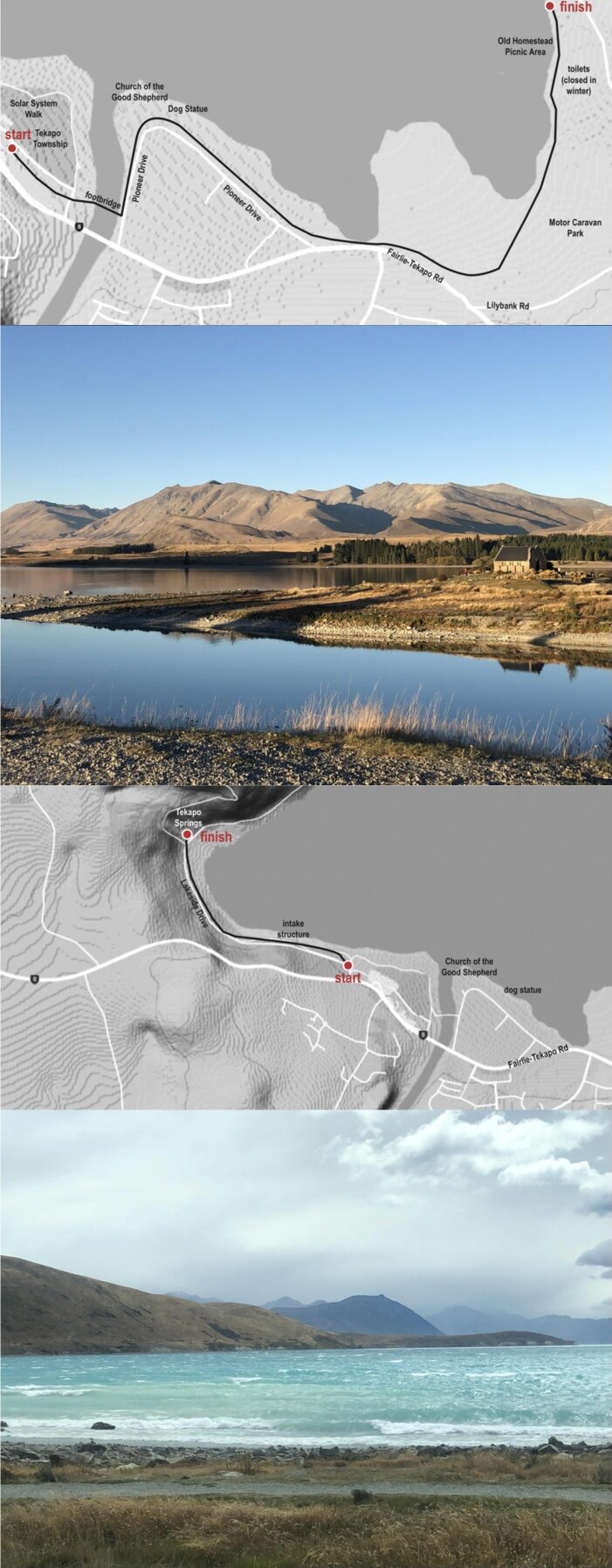
Township to Pines Beach Trail
Walk, run or MTB (Grade 1-2).
Distance: 3.5 km one way
Description: This easy, flat and gravelled trail follows the Tekapo lakeshore from the Township to Pines Beach where it is safe to swim and boat. The trail has been extended 1.2km to Willow Bay. Please use the toilets located at the Homestead Carpark and take your rubbish out. Leave no trace.
If biking, once past the Dog Statue please be considerate and use the road or the lower track when it is busy to allow for groups of walkers and families with pushchairs. Rejoin the gravel path at the end of Pioneer Drive.
Getting there: From Tekapo Township, cross the footbridge and follow the lakeshore on the gravel path into the Regional Park. Return any which way and if you have small children there are plenty of places to rescue them with a vehicle when they won’t walk any further!
Township to Tekapo Springs
Walk, run or MTB (Grade 1-2).
Distance: 2.8 km one way
Description: This easy, flat and gravelled trail basically follows the Tekapo lakeshore from the Township to Tekapo Springs and the start of the Mt John Walkway.
Getting there: From Tekapo Township, walk to the front of the supermarket, around the end of the wooden fence to a gravelled carpark and past Bespoke Cycles. Cross Lakeside Drive and pick up the gravelled trail above the lake, use the pedestrian crossing onto a sealed path and cross back again to the lakefront in front of the motorcamp to the finish.

Richmond Trail
Walk, run or MTB (Grade 4).
Distance: 13 km
Description: The trail travels along an old glacial terrace below the Two Thumb Range through tussocks and patches of native vegetation, mostly matagouri. On a fine day you get sweeping views of Lake Tekapo and the surrounding mountains. It is a steep descent above Boundary Stream on the way back to Lilybank Road but apart from that the trail is open and easy.
The trail starts and finishes in different places so two vehicles are a good idea, although for the fit, park at the Boundary Stream Carpark on Lilybank Road and bike the 24 km up to the start of the track just below Roundhill Skifield.
Richmond Trail is best cycled in a clockwise direction as it is mostly downhill, or simply walk from the start until you have had enough and return the same way – the views are completely different.
Getting there: From Tekapo Township, travel east and turn left into Lilybank Road. If starting at the Carpark below the skifield, it is a 35 km drive. If doing the whole circuit, the Boundary Stream Carpark is approx. 13 km up Lilybank Rd.

Peninsula Trail
Walk, run or MTB (Grade 2 -3).
Distance: 5.6 km
Description: This easy, popular circuit offers beautiful views of Lake Tekapo and Lake McGregor from a very different angle to what you see from Tekapo township. It is a DoC track marked with orange poles but sometimes a little hard to find amongst the rosehips so look carefully. At the northern point it is worth walking down to the lakeshore (dotted line) and turning south for a short way to get a closeup view of the white cliffs you look across at from Lilybank Rd. Their chalky texture are very striking in the morning sun. This is unmarked so just climb down the bank where it is low and easy. The trail is open all the way. You must use the public toilets in Tekapo before you venture out. All rubbish must be taken out. Leave no trace.
Closed for lambing mid-October to mid-December.
No dogs, no exceptions.
If MTBiking, it is advisable to take the right hand fork but take care on the steep descents. If going in the opposite direction, you may have to push your bike on two short uphill sections.
Getting there: From Tekapo Township, travel west and turn right onto Godley Peaks Rd.
Drive 5.7 km to a small carpark on your right.

Mt John Walkway
Walk, run. Dogs on a lead. Cell phone coverage.
Bikes on 4WD track on lakeshore only. Bikes on 4WD track on lakeshore only.
Distances:
Mt John Walkway Circuit ,8.5 km
Tekapo Springs to Mt John Summit – 1.5 km
Tekapo Springs to South Summit Circuit – 2.8 km
Description: This trail is uphill all the way to the top but many zigzags make it possible for most people. The first part of the trail is through the trees to a seat overlooking the lake. Continue through the small gate, until you come out into the open. Pass another seat and either take the trail on the right to the South Summit or continue over the stile on the Mt John Walkway. A side trail marked on the right will take you to the Astro Café on the summit, or continue on the loop, crossing the road until another stile. From here follow the well worn track down the ridge and complete the circuit back to Tekapo Springs.
The circuit can be undertaken in either direction but local advice is to go clockwise and enjoy the expansive views as you head down the Mt John ridge and return along the lakeshore.
Getting there: Walking - from the Tekapo township, walk following the lake behind the supermarket and onto a concrete path. Follow this path to the start of the trail on your left just before Tekapo Springs
Driving - drive west not far on SH8 and turn right onto Lakeside Drive. The trail starts on the left before Tekapo Springs. Car-parking is available close to the trail at the end of the road.